by Lisa LaFleur (an avid traveler, always seeking out adventures)
Lisa shares her writings and photos with Global Adventuress community:
“For 2013, I chose to leave the passport at home and explore national parks here in the US. I’m always drawn to the mountains, to the granite, the peaks, the alpine lakes, the altitude, the beauty of the surroundings. Lake Tahoe and that portion of the Sierra Nevada range is in my “backyard”, a 1.5 – 2 hour drive gets me to many trailheads year round. But for the last 3 summers, I’ve chosen to drive 4.5 hours to get to the eastern Sierra’s, making Mammoth Lakes my base camp. It’s a strong attraction, much more than Tahoe, and well worth the drive. having just recently returned from a fantastic 5-days of hiking and kayaking in the area, I figured I’d share the experience – with some photos, some trail and kayak info, and hope to inspire others to explore this scenic area. I’ve already set aside some time to return in October, should catch some spectacular fall colors with the abundant aspens).”
Saddlebag Lake to Twenty Lakes Basin loop trail
The loop is 5 miles roundtrip; it’s a 1.5 mile flat trek on the trail around Saddlebag Lake to the trailhead. The resort cafe provides a basic “map” route of the loop and identifies the lakes.
This is a wonderful, scenic, easy trail in the high country of the eastern Sierra’s (starts at 10,087 feet and climbs to 10,400), that leads to numerous lakes with an abundance of wildflowers to surely brighten your day. So on both accounts, keep your camera handy. The hike is exposed for the majority of the trek, so at this altitude, don’t forget sunscreen; and mosquitos can be a nuisance also. This trail is a swimming dog’s delight, with loads of opportunities to swim and keep cool. This is also a very popular fishing area, so bring your pole if so inclined, and be mindful of the fishermen if you do have an off-leash k9 companion.


You can take the water taxi to the trailhead ($12 roundtrip, $7 one-way, $5 roundtrip for dogs – buy tickets in the cafe; it’s less than a 10 minute excursion). If you choose to walk to the Lake Basin trailhead, I prefer the eastern side of Saddlebag – It has intermittent shade and a flat dirt trail with occasional water access for k9s; this trail begins at the end of the resort parking lot, just beyond the restrooms. The western-sided trail begins near the dam and you walk along a metamorphic rock slide, without trees or shade. The eastern side trail eventually passes an old forest service cabin at the far end of Saddlebag Lake and just beyond that, the trail veers right and you’ll see a sign indicating entry into Hoover Wilderness – a starting point for the loop trek. My preference is to do the loop in a clockwise direction – so if you continue to walk along the lake, you will reach the boat taxi dock and meet up with the loop trail again, and another Wilderness sign as you begin the trek in a clockwise direction.
The trail is relatively easy, the only “climb” is after you leave Helen Lake up a narrow valley in rock scree. At the top of this, you are now above yet another lake, Odell; you have to look hard for some trails to get down lakeside. I had to do some route finding once I passed the directional sign for Helen Lake. The well trodden trail wound around Steelhead Lake and eventually took me in the wrong direction (another hiker I met, looking for the trail also, thought we were headed to a tungsten mine). Tracing my steps back, I did some off trail walking in the direction I believe I should be headed and intermittently did pick up a trail leading to Shamrock Lake – picturesque with rock islands; worthy of a snack break and photos. You see a hint of the trail as it leads onward towards a rock slide area, once crossing in the slide area, you can feel confident you are on the path. Then it takes you down some rocky switchbacks to just above Helen Lake.
Once you’ve left Odell Lake, you descend through a green valley to small Hummingbird Lake and soon after you’ll spot Saddlebag Lake down the trail. At the trail junction, you can veer left to follow the Saddlebag Lake trail back to the cafe or head to the right to catch the water taxi (and remember, your dog must be dry to board the taxi – not easy with so much water access!) once you’ve made your way back to the cafe, consider treating yourself to a piece of fresh pie while sitting outside the cafe and reflecting on your wonderful day.
How to get to Saddlebag Lake:
Travel west on state route 120 from the junction with US highway 395, just south of Lee Vining. This is clearly marked as an entrance to Yosemite National Park by way of Tioga Pass Road (120). There is a very convenient Mobil station and deli immediately to your left once you’re on route 120 – to stock up on forgotten grocery items, full deli and hot meals served (outdoor dining available), gift shop, clean restrooms, gas and a scenic vista of Mono Lake. Travel 10 miles up Tioga Pass Road and just beyond Ellery Lake, turn right (North) onto a signed road for Saddlebag Lake. It’s about 2.5 miles of unpaved road that leads to free parking at the cafe/resort (there is a sign for trailhead parking just before the end of this road, but you can continue onward to cafe).
Sunrise Lakes to Sunrise High Sierra Camp (HSC)
It’s a 8.5 mile roundtrip to Upper Sunrise Lake and 10 miles roundtrip to Sunrise High Sierra Camp; upper Sunrise Lake is at 9000 feet for a gain of 1100 feet from the trailhead.
These lakes are situated above Tenaya Lake, west of Tuolomne Meadows, inside Yosemite National Park. By the time you’ve driven here, from either direction on state route 120/Tioga Pass Road, you’ve undoubtedly been in awe of all the dramatic sights – lakes, peaks, meadows, creeks, wildflowers and maybe some lucky sightings of rock climbers or wildlife (and of course many people and cars if you’re here on a summer weekend). This trek is on the John Muir Trail, so you’ll likely encounter “through hikers.” I always enjoy stopping to talk to these folks and hearing of their adventures on the trail. On returning from the upper lake, I met upon a Dad and his 8.5 year old twins – they had backpacked in to the Sunrise HSC from the Cathedral Lakes side and spent the night. They were treated to great views and good food at the camp, and were now heading over to Glen Aulin HSC. The kids had matching backpacks, boots and sun hats, were quite talkative and obviously enjoying their first backpack outing. We parted ways at the trail junction – they were headed for lunch at the Half Dome viewing spot and I was headed down trail, back to Tenaya Lake.
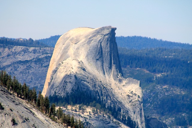
The trail starts out just behind the bathroom and is paved for a short distance, the sign will indicate Sunrise HSC 5 miles. It’s a quiet, tree-lined walk along an outlet creek from Tenaya Lake for the first 1.5 miles. Then the trail climbs thru switchbacks and rocky footing for just under a mile, and emerges at an open ridgeline at 2.3 miles. You will see a sign to your left/east for Sunrise and another for Clouds Rest. I highly recommend you take a detour along an unsigned trail to your right for about 300 yards – this leads to a stunning view of Half Dome, Tenaya Canyon and Yosemite Valley. There are a few great boulders to sit on and gaze over the landscape. A telephoto lens will capture a great view of Half Dome.
Not far from this junction, after easy hiking you will arrive at Lower Sunrise Lake, and if you’re lucky like I was, it may be quiet and empty – another opportunity to sit and reflect on the surrounding beauty. Off to the East, the lake is bordered by a large talus slope. Continue onward and you will eventually get a glimpse of Middle Sunrise, to your left – there supposedly is a spur trail, but I couldn’t find it; so I made my way across the open terrain of boulders and trees, marking my route with cairns. This is the most secluded lake of the three, with some small rock islands and a green grassy shoreline, making for a quiet lunch spot. Once back on the trail, you will quickly arrive at Upper Sunrise. If you choose to go to the High Sierra Camp, it’s a half mile from the end of the lake.
Once you’re back down at Tenaya Lake – consider a paddle on the lake (if you have your kayak or canoe) or relaxing on the beach. If you’re heading out east on Tioga Pass Road, don’t miss out on an ice cream frosty at the Tuolomne Meadow Grill. There’s a post office here too, so you can send off a postcard to share the highlights of your trek.
How to get to Sunrise Lake trailhead:
The trailhead is on Tioga Pass Road/State Route 120, on the Southwest end of Tenaya Lake (8.5 miles west of Tuolomne Meadows campground). It’s a small parking lot, but you are able to park along the road. It’s Tuolomne Meadows bus shuttle stop #10.
Little Lakes Valley in the John Muir Wilderness
There are literally lakes around every corner on this trail – probably my favorite of the many I’ve done in the eastern Sierra’s. I think some of my bias comes from watching my Labrador run from lake to lake and swim in them all and still, after 8-10 miles of hiking, want to swim in the outlet creek once we return to the car. Besides the lakes, there are 13,00 foot mountain peaks and wildflowers that will take your breath away.
The trail starts at 10,300 feet and gets to 11,100 at Morgan Pass; Gem Lake is just below Morgan Pass, about a 3.5 mile trek. Less than a mile from Gem Lake, you can take a trail to Chickenfoot Lake (the name alone beckons you) that is at 10,789 feet and a 5.6 round trip trek. (the trail junction is at the far end of Long Lake, trek another .7 mile). If interested, you can include a hike up to Ruby Lake at 11,121 feet; the trail junction is .5 mile from the parking lot. You climb switchbacks, often on loose sand and exposed to the sun, but you get a spectacular view of the Little Lakes Valley that is worthwhile.
This is a very popular trail and destination, once you’re there, it is obvious why. With so many lakes to stop and enjoy, it never seems crowded. It’s a very gentle grade all the way to Gem Lake.
On the drive in to the trailhead, consider stopping at Pie in the Sky Cafe for a slice of pie – to put away in your ice chest for later (we waited until AFTER our hike on our first visit to the area, only to be disappointed that our favorite berry pie was sold out!). It’s just beyond the Rock Creek campground on your right and only has 2 small parking lots.
How to get to Little Lakes Valley
I believe this is known as the Rock Creek area. From Mammoth Lakes, travel south on US Highway 395, 16 miles to Tom’s Place and turn right onto Rock Creek Road. Drive thru an aspen lined road 10.5 miles, road ends in the parking lot of the trailhead; large lot, but popular destination. Bathrooms available at trailhead. Water access right away – creek next to parking lot and hike starts out along side the creek – for those eager canines.
Sherwin Lakes
This is an easy, short hike, right in Mammoth Lakes, that I do the morning I’m heading back home (it’s only 2.5 miles from where I stay). It’s 5.8 miles round trip, start at 7800 feet and you’re at 2 lakes at 8640 (a good pace can get you there in less than an hour).
The trail is fairly exposed and mostly on soft sandy terrain for the first mile of switchbacks. Then it’s gets more rocky under foot and the climb intensifies a little before leveling out. At 2.5 miles you come to the first Sherwin Lake, the smaller of the two, and just around the corner is the next one. Both have open beach areas for easy swim access for both humans and k9s.
How to get to Sherwin Lakes
From US Highway 395, exit at 203/Mammoth Lakes and follow this to Old Mammoth Road and turn left (south) and travel .8 mile to Sherwin Creek Road (at corner of driving range). Drive on paved and unpaved road for 1.3 mile to a signed right turn for the trailhead, follow this unpaved road .4 mile to parking. Restroom available. If hiking with your dog, only .2 mile in is Sherwin Creek for a quick drink and swim; no more water access until you reach the lakes.
Kayaking options in the eastern Sierra’s
With so many lakes, having a watercraft to get on the lake is a bonus. I’ve had my kayak a couple times with me and the routine is to hike first and end the day with a paddle on one of many alpine lakes (all very close to trailheads). Each lake I’ve paddled has required me to use my kayak wheels to transport boat from car to water if alone, otherwise it’s a 2 person carry.
I’ve stayed in June Lake and paddled that lake (one of 4 available) – easy access to beach from parking lot. I’ve also paddled Lake Mary and Twin Lakes in Mammoth Lakes. These are small lakes, quiet paddles, an easy late afternoon outing.
On this most recent trip, I explored some new venues – 3 were lakes I’ve been longing to get my kayak on and one was a repeat; I had a fourth new one on my wish list, but after a long hike and windy paddle on Tenaya Lake, I was surprisingly too tired to paddle Tioga Lake on my way back to my June Lake lodging.
Ellery Lake
After my venture thru Twenty Lake Basin, I stopped at Ellery Lake on Tioga Pass Road – every time over the years that I’ve driven by this lake, I’ve just marveled at the scenery and dreamed of being on the water. I first drove in to the Ellery Lake Campground only to see a sign that day visitors not allowed access. There is a small gravel lot just above the campground, accessible off Tioga Pass Road, so I pulled in there and scouted out the area. To access the water, I’d have to get my kayak down a moderately steep rock and dirt trail. One truck had back downed this route but I didn’t trust my driving skills to back into a narrow opening between trees and then to get my 4WD SUV back up the hill. So I put the 4WD kayak wheels on and found it not difficult to get the boat down to the water. It was an easy 30-40 minute paddle to circle the entire lake, but so relaxing and scenic (and worth the effort hauling the boat back up the hill in wet Tevas).
Tenaya Lake
After the trek to Sunrise Lakes, I paddled on Tenaya Lake in Yosemite National Park, this was the repeat. As it was right next to the trailhead I had just done and I got parking right next to the beach, I couldn’t pass it up. If you’re fortunate, there are parking spots near the beach. This is a very popular lake for fishermen, beach goers and picnics; so be prepared to find it quite busy. Restrooms are available. This is a bigger lake than Ellery, but still only took about 45 minutes, on a windy afternoon, to complete the circuit. You paddle past some great boulder shorelines and on the far shoreline, you may be treated to wildflowers as I was in July.
Mono Lake
Another new venue and one I’ve been pondering for a few years, was to get my kayak on Mono Lake and paddle amongst the tufas! It was otherworldly to be up close and see these formations from a new perspective. There was 3 of us, and we had them all to ourselves. You are advised to be off the lake by noon due to high and unpredictable winds. So as we launched shortly before 9:00 a.m. we were surprised and delighted to have PERFECT conditions – not a ripple on the lake and not a breeze in the air. It stayed like that for just over an hour and then a progressively stronger breeze started and we were off by noon and avoided any wind.
Besides the up close views we were treated to “fly-bys” from the water birds – they float amongst the tufas (we presume feasting on the brine shrimp) and if we came too close, the flock would take off, skim the water and buzz us with a fly-by. The formations were unbelievable to watch and the sound they made was loud and astonishing. We also saw 3 or 4 osprey nests on top of some of the taller tufa towers, each had one parent sitting in the nest, protecting young offspring; we intermittently would catch a glimpse of a young head popping above the nest’s edge.
The launch site to paddle to the South Tufas is from Navy Beach. 5 miles south of Lee Vining on US Highway 395, you exit onto State Route 120 East and travel 5 miles of paved road. you will come to a sign for South Tufas, turn left and shortly beyond that is a right turn, signed for Navy Beach.
Rockcreek Lake
On our way into Little Lakes Valley, we started the day with a paddle on this very picturesque alpine lake (it’s a left turn at Rockcreek Campground). Easy launch from a sandy beach next to the parking area and restrooms. Small lake, casual paddle, allowing ample time to relax and soak in the scenery. If we didn’t know what wonders the hike held, we could have stayed longer on the water (and we wanted to pick up our slice of pie BEFORE we hiked; and I’m thrilled to say my favorite, boysenberry, was available!)